Sunday, August 23, 2009
Sunday, August 16, 2009
Last flight over the Atlantic for this part of the trip, England to Sweden to visit friends in Lund
We've just had the most wonderful English breakfast. Anyone planning to visit Durham in North England should consider staying at the Cathedral View Town House, if only for the outstanding breakfast!
Durham is lovely. We toured the castle yesterday, which is now used for student residences, if you can believe it. Lucky kids, it's an amazing Norman castle dating back to 1070. The cathedral is right next door, and was described by Bill Bryson as the "most beautiful cathedral on planet earth". Unlike many other cathedrals, it is fully open to the public and no sections are closed off from view. Stunning.
Today I fly my last transatlantic leg of the tour - as I am flying home commercially on the 20th, Eli and our friend Dan have lots of transatlantic travel ahead of them, but this is likely my last day in a survival suit for a while. I've come to kind of like it~! For someone who is perpetually chilly, the survival suit poses less discomfort.
I'm very excited about Sweden, which is one of my favorite places. We will fly into Malmo, close to Denmark, then take the train to Lund, where my dear friends Tomas, Lena, Anges and Edvin live. I look forward to introducing them to Eli, who they have not yet met. We don't see each other enough, but when we do, it is always magical.
After Sweden, we'll likely trundle down to Austria to see Eli's cousin and his family. Then homeward bound!
Friday, August 14, 2009
The Final Push: Reykjavik - Vagar - Prestwick (BIRK-EKVG-EGPK)
Eli: Thursday morning we were wheels up from Reykjavik a little later than expected as the fuel truck at Flight Services was making its once a month rounds around Iceland refilling local airport AVGAS depots. We decided to do a combination of visual and instrument flying enroute to the Faroe Islands.
We took off Runway 31 northwest and immediately did a left 270 over the city leveling off at 1,200 ft. just below the cloud deck. The terrain gradually rises east of Reykjavik and for a while I wasn't sure whether our plan to do some low level sightseeing was going to work.
The previous night we had found a gigantic map of the country on the outside of an Icelandic tourist office. Fortunately it was a real map with lat-long markings and we were able to roughly determine the coordinates for a number of significant sights we had wanted to see. We manually entered these coordinates into our GPS and set off for a) Iceland's famous gesyer, b) Thingvillir, the meeting or the North American and Eurasian techtonic plates, that was the inspiration for Jules Verne's Journey to Centre Earth. and c) the massive deep waterfall, Gullfoss, which does look like it flows into the Earth's core.
Iceland is amazingly relaxed about its VFR flying compared to most countries. Air traffic controllers happily kept an eye out for us and we did numerous low level passes and circled overhead. We were able to take some spectaular shots that we'll eventually post on this blog.
After getting our fill of gushing geysers and rushing waterfalls, and as always conscious of our fuel reserve, we picked up our IFR clearance about 40 nm north of the airway that would eventually take us directly to the Faroe Islands. We were cleared to 13,000 feet, through and above all the weather and settled in for a smooth ride across south Iceland, and over the open ocean to Vagar in the Faroe Islands.
The weather in this small Danish holding was forcast to be excellent, which was a good thing since there weren't a multitude of alternate airports should the weather suddenly go down. Our alternate airport was Wick at the tip of northern Scotland, which would have required ultra-economical flying to make it there with a legal fuel reserve if we had to go missed in Vagar. A 15 knot tailwind was an added bonus and helped make up for the fuel we used VFR flying and more importantly added to our mental reserves.
From the air, the Faroe Islands look like a luscious golf course for the Gods with each island being a separate hole with the odd water trap in between. The visual approach into Vagar was probably the most beautiful of the entire trip, as we circled the southern bluffs of the islands, turning northeast at a waterfall and then settling into a valley, the landing strip bordered by lush, groomed grass on either side.
We were met on arrival by the CFO of the airport, who makes it a point of taking a photograph of all private aircraft that arrive in Vagar. Normally we're not big on hanging out in airport terminals but the airport's Danish modern design and furniture, complete with large Lego blocks for the children, made us opt for an indoors picnic (we ate sandwiches made from our hotel's breakfast buffet offerings in Reykjavik!).
Bren and I ascended to the control tower to file our flight plan for the final leg of our trans-atlantic crossing. The routing, which to our surprise was immediately accepted by Eurocontrol ATC in Brussels was:
EKVG direct MY, direct ORKAR, STORNOWAY, GLASGOW, direct EGPK
Setting out from Vagar, Bren and felt much like rider wearing the yellow jersey on the final leg of the Tour de France. We could taste the finish line and as long as we kept our cool and did nothing stupid, victory would be ours.
After reaching Stornoway, Scottish ATC intiated "deconfliction" service and cleared almost directly to Prestwick. We set up for a nice long ILS glideslope final approach into Prestwick, the runway lights sparkling in the twilight. Just to add a bit of drama to what had otherwise been a very uneventual series of flights, we had avoid a flock of seagulls just 300 feet above the runway, directly on the glideslope. It was a good thing I was manually flying the approach.
We landed in Prestwick without incident and settled in for a night of celebration in the nearby seaside town of Ayr, post-landing beers, local curries, and karaoke with the locals!.
Anyway that's it for now. It's been a fabulous journey totalling about 33 hours flight time over the course of nine days. Thanks for sharing our trip with us. Bren will write more later.
Vancouver Sun posts wrap up story on us arriving safeley.
http://www.vancouversun.com/life/Local+couple+reach+Europe+Cessna/1892140/story.html
Thursday, August 13, 2009
Tuesday, August 11, 2009
Flight Log August 10 2009: Greenland to Iceland
Eli: Monday morning I double and triple checked the weather before our ssetting off first across the massive Greenland icecap, and later the Denmark Straight to Iceland.
We were originally cleared to 12,000 ft. but held soon after takeoff at 5,300 as we waited for an incoming Greenland Air flight to pass off our left. It was amazing that in an area of such open expanses, two planes could still pass so close.
At flight level 120 the winds were still light and variable and the temperature about -10C, just warm enough for a little frost to form on our wings as we passed through the top of some small clouds. A quick call to ATC, a climb to 13,000 and we had no further cloud encounters until we landed in Kulusuk.
Our transition altitude to Kulusuk was 8,000 ft. As you'll see later from the photos, Kulusuk is at the base of huge fjords with the accompanying high mountains. I decided to stay relatively high until I was over the Kulusuk non-directional beacon, at which point I performed the full procedure NDB teardrop approach http://www.slv.dk/Dokumenter/dsweb/Get/Document-814/BG_AD_2_BGKK-NDB-11_en.pdf It provided me with a great way lose altitutde and also an excuse for more fantastic scenery both outbound and inbound.
Unlike Stony Rapids, Kulusuk is a real gravel runway so my most gentle landing techinque possible was employed. As we back-tracked to the terminal, a large Fokker had already taken its position on the strip, it's pre-takeoff lights staring directly at us.
When it was time to leave, I was directed up to the Control Tower where to the controller had already prepared a draft flight plan for me, complete with enroute time estimates and updated weather. After getting my sign-off, he entered my plan with Reykjavik Oceanic Clearance. Of course all this service comes at a price.
First, on the subject of fuel, the good news is that I didn't have to buy it by the drum. A small trailer pulled up to the plane and a mechanical pump topped off the tanks in no time. The bad news is that it cost just about as much as if I had bought a drum or two. In addition to my mile high fuel bill was added a variety of handling and service charges. Still I was just glad to have the fuel and services available. Still, the peace of mind of taking off across a large stretch of open water knowing you've got full tanks is worth it. It wasn't that long ago that being able to find Avgas at any price was difficult.
Our sequence of hand off from Greenland to Iceland was: Kulusuk AFIS-Sondrestrom Information-Iceland Radio-Reykjavik Approach-Reykavik Tower. At the point of crossing from Greelandic into Icelandic airspace we had difficulty getting a message to Iceland ATC. An Air New Zeland flight along with a private ferry pilot graciously offered to relay our position and enroute waypoint estimates through the Oceanic air-to-air frequency of 123.45.
The weather held wonderfully for our descent into Reykjavik. Just a little bit of cloud at 4,000 ft. offshore with a couple of rainbows thrown in for good measure while skies were clear over the airport itself. When we pulled up to the general aircraft terminal, we were marshalled by an attractive redhead in a mini-skirt and high heeled boots. As Bren said "We're not in Kansas anymore - Welcome to Iceland".
Monday, August 10, 2009
After picnicing in the most beautiful place I have ever seen, we flew safely to Iceland and are now at our Hotel in Reykjavik.

Bren: We have just arrived in Iceland. After we shower and unpack, we are off to explore the restaurants and night life a bit. We'll be here for two or three days, and hope to go trekking on Icelandic ponies, as well as getting out to see the geysers and hot springs Iceland is famous for. However, we've not yet told you about the most wonderful place we visited today, Kulusuk Greenland.
Kulusuk is a small stop over on the East Coast of Greenland. No one had mentioned it's beauty to us before we arrived there, and as we approached, we were in complete awe. We flew over the icepack, and on the edge of the giant glacier, where it meets the sea, are the most stunning moutains and clear artic blue water. There are icebergs everywhere. These are the first icebergs we've seen on the trip, and they were shockingly beautiful in the variety of shapes and sizes they took. Some were as large as football fields, others the size of Eli's smart car. After an impressive "vietnam style" landing on the gravel runway, we parked MDS with a gas attendant and walked to the fjord at the end of the runway to have a picnic amongst the icebergs. It is truly the most beautiful place I have been, and I felt both in awe and greatly priveledged to be there. I took 200 photos today, and of those I hope a few will capture at least some of this unique and pristine scenery.
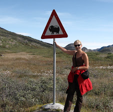
As we were eating our sandwich and gatorade, I stared to consider the liklihood that a polar bear could be in the area. It was a perfect setting for one - he could swim from iceberg to iceberg hunting seals, or perhaps the rare tourist picnicing on the edge of the fjord. That thought ended our picnic rather abruptly, as we decided to make our way, swiftly, back to the airport.
The flight to Iceland was without incident.
Sunday, August 9, 2009
Of Feast and Planning
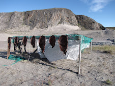
Bren: Tonight we took part in a traditional Greenlandic feast. It was scrumptious, with some surprising new tastes that might need to grow on a person to fully enjoy them. I think the polite terminology would be "an acquired taste". Here are some of the items served: poached trout (as big as a coho), many types of salmon, halibut, scallops and muscles, muskox and reindeer carpaccio, three types of whale (including 'white whale' and 'Greenlandic whale'), with a wild Greenlandic blackberry cake for dessert. I think we'd call these blackberries huckleberries or wild blueberries in the pacific northwest. I declined to the whale, but did enjoy trying the other unique offerings.
Earlier in the day we went on a Muskox viewing tour but were shut out. There is a large group of people who arrived on a small cruise ship earlier in the day and our guide theorized that the sheer number of tours may have driven the muskox further into their range. It is hard to describe the enormity of the landscape here - if you think the "big sky" images you may have of Montana, where the mountains and valleys and ranges continue for as far as the eye can see, it is a similar scope. However the scenery itself is so unique, I have a hard time relaying words to descirbe it. I could imagine a brontosaurus wondering on the hills outside our hotel and it would completely suited to its landscape.
We spent some time this evening doing our pre-flight inspection of MDS. We're pleased to note that we've been burning on average a litre of oil every six hours of flight. We topped it up tonight for our long journey tomorrow. Tomorrow we fly to the other side of Greenland, fuel up and strech our legs, then push onwards to Iceland. I will try to post as soon as possible when we arrive, given the unreliability we have been experiencing with SPOT, and how that has risen the blood pressure of a few of our friends and family. Here is our plan for tomorrow. We'll be wheels up at 9am local time. We expect a low pressure system in Iceland to be clearing in the early afternoon.
Sandrestromfjord to Kulusak (343 Kt m) + Kulusak to Reykjavik (408 Kt m) = 751 kt m
Routing: Sonderstromfjord (BGSF) to Kulusak (BGKK) via W28. Kulusuk (GBKK) to DA (Waypoint) to 65N30W to Gimili to Reykjavic (BIRK).
Next blog from Iceland!
Saturday, August 8, 2009
Saturday August 8 2009 CYFB-BGSF
Eli: Today was one of those magical flying days thanks to some great weather and alot of cooperation from people on the ground.
We were wheels up from Iqaluit at 9:12 am local time. It always seems to take a little extra time to prepare survival equipment for the over water legs. Despite earlier predictions for a layer of low marine fog over Frobisher Bay, skies were blue and winds were calm. We were able to turn almost immediately on course, first to a waypoint at the border between Canadian and Greenlandic airspace and then directly Sondrestrom Fjord/ Kangerlussuaq Airport. Winds were not quite as favourable as promised but we were still able to average about 130 nm/hr.
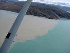
Bren took some great shots as we made landfall, the Greenland coast. No matter how smooth the plane is running, it's always a relief to see terra firma rising up to greet you. Rising up is literally the case along Greenland's eastern shores. We had just descended to 9,000 feet and it seemed that we were practically level with the coastal mountain tops. Following vectors up the fjords - first around Holsteinborg and then joining Sondrestrom Fjord proper - it felt like the land was a detailed map unfolding in front of us. The airport came into view when we were about 15 nautical miles to the west in near perfect meteorological conditions and we were cleared for a visual approach to runway 09.
Our hotel in Kangerlussuaq is part of the airport terminal and was once the officer's quarters for the American airbase that was situated here from 1941-1992. Finally we have a good hi-speed Internet connection and are looking forward to uploading some great photos we've taken along the way.
Flying a Cessna 182 into Greenland is the aviation equivalent of backpacking with a Volkswagen Beetle. I definitely feel I'm getting back to my Eurorail Pass roots. People though have been very welcoming and treating us like adventurers rather than tourists. It's also a good excuse for not shaving!
We were wheels up from Iqaluit at 9:12 am local time. It always seems to take a little extra time to prepare survival equipment for the over water legs. Despite earlier predictions for a layer of low marine fog over Frobisher Bay, skies were blue and winds were calm. We were able to turn almost immediately on course, first to a waypoint at the border between Canadian and Greenlandic airspace and then directly Sondrestrom Fjord/ Kangerlussuaq Airport. Winds were not quite as favourable as promised but we were still able to average about 130 nm/hr.
Bren took some great shots as we made landfall, the Greenland coast. No matter how smooth the plane is running, it's always a relief to see terra firma rising up to greet you. Rising up is literally the case along Greenland's eastern shores. We had just descended to 9,000 feet and it seemed that we were practically level with the coastal mountain tops. Following vectors up the fjords - first around Holsteinborg and then joining Sondrestrom Fjord proper - it felt like the land was a detailed map unfolding in front of us. The airport came into view when we were about 15 nautical miles to the west in near perfect meteorological conditions and we were cleared for a visual approach to runway 09.
Our hotel in Kangerlussuaq is part of the airport terminal and was once the officer's quarters for the American airbase that was situated here from 1941-1992. Finally we have a good hi-speed Internet connection and are looking forward to uploading some great photos we've taken along the way.
Flying a Cessna 182 into Greenland is the aviation equivalent of backpacking with a Volkswagen Beetle. I definitely feel I'm getting back to my Eurorail Pass roots. People though have been very welcoming and treating us like adventurers rather than tourists. It's also a good excuse for not shaving!

Friday, August 7, 2009
Spotty Spot
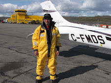
The good news is the flying has been great. CFMDS, my Cessna 182 has done everything I have asked of it thus far. I truly appreciated the high wing design of our plane today, as it was raining steadily in Rankin Inlet this morning, and Bren and I were able to take shelter under the wings while arranging luggage, charts and donning our survival suits.
On the other hand communications technology has been a source of frustration. Many of you have noted that our tracks from our Spot tracking device have on occasion been late showing up. Also, Spot failed to record our leg from Stony Rapids to Rankin Inlet. Fortunately I'm not relying on Spot as a primary emergency locator transmitter, but if I was, I would be feeling a little queezy in the air.
Internet communication has also been difficult. Finding a connection to file this blog and check email is a constant challenge. Little did I realize that Rogers doesn't service the North, only Telus and Bell.
On a positive note, the highlight of today's flight for me was flying over Coral Harbour in northern Hudson's Bay and discovering how aptly it is named. The tropical turquoise waters, surrounding islets that resemble submerged Mayan pyramids made me think of my similarly coloured 57 Chev minus the tail fins.
On a technical note, I was surprised to learn that though I was in uncontrolled airspace for most of the trip, I was not off the radar, so to speak. Air Defense Radar, a product of NORAD and the Cold War ensures that planes are well tracked even if radio communication with air traffic control is not possible.
Our adventures in refuelling were easier today. We still had to buy fuel by the drum but at least this time two refuellers rolled our drums and used an electric pump (jump wired to their truck battery) as opposed to the hand pump yesterday. Cost for the drum was $440 - we were warned to expect about $800/ barrel in Greenland.
Speaking of Greenland, the weather is looking good for tomorrow. We've done all our flight planning, reloaded the Atlantic (European) database into our main GPS and established a waypoint for crossing into Sonderstrom's Flight Information Region. We've been warned several times not to arrive after 1845Z lest we be charged $900 USD for an after hours fee for keeping the airport open.
An additional advantage of travelling to Europe in a small plane is that one doesn't suffer jet lag. We have been losing on average an hour a day as we cross time zones and am merely pleasantly fatigued at the end of the day. In fact I can feel that fatigue setting in right now. Off to dream about approaches up coastal fjords.
East of Coral Harbour, we witnessed at least 30 belugas playing in the turquoise water of west Hudson Bay. Rafi anyone?
We flew what is likely to be our longest leg today - 644 Nautical miles, over Hudson Bay. My expectations of what it would look like were off - there is little to no ice and snow, and the water, in some parts was as turquoise as the Mediterranean. Spotting the whales was a huge highlight for me, I can add one more species to my list of "whales I have seen in the wild". They join the Orcas we paddled with off Victoria, the Humpbacks in Alaska, and the gray whale I kayaked with in Sooke Basin some years back. The belugas are, of course, easier to see given their bright white bodies in the calm Hudson Bay waters we were fortunate enough to have today. Paddling with whales is extraordinary, but viewing them from the plane has it's advantages, particularly being able to see them as they are underwater and watch their antics as a whole group. It was amazing.
We flew in the immersion suites today, and had been concerned that they might be difficult due to their bulkiness and warmth. Quite the opposite, we were very comfortable and neither of us found them overly awkward. Goofy looking, but not awkward. We had reviewed our plan should we have a mechanical failure and need to ditch. Our third passenger is a six person life raft, with the pull cord latched to the seat belt. Upon release, it automatically inflates, and there is a soft release cord in case the plane were to go under. The stats would be in our favor - 85% survive ditching a small plane. However, of that, only 50% survive the time in the water. We can't mitigate the first number, but we can do a lot to ensure that were we to have to ditch, we'd be in that second 50%. However, it is our intention to never have to test our preparations, and to have a well planned trip where we ensure our safety by being patient and flying when the weather is inviting.
The weather was on our side all day today, and our luck continues. We are prepared to be grounded somewhere due to poor weather - we know it is likely to happen at some point, but, knock on wood, we've not run into anything worse than a bit of rain. This just saves me from having to scrub off all the dead bugs after our flight, so I'm personally quite grateful for it. We were flying at 5000 or 6000 feet most of the day, and the temperature at that level was between 8 and 11 degrees C, so icing was not an issue.
We're excited to explore Iqaluit. It's much larger than the last few towns we have been to, and has approximately 6500 inhabitants. It has the feel of a space station, the buildings are cube shaped and industrial looking. It seems everyone we meet are either contract tradesmen or surveyors. The hotel people are all bemoaning the loss of the explorer dollar - it seems that mineral exploration has dropped off due to the recession and had once been a major source of tourism. It seems there is a certain type of person drawn to the North, and everyone we have met love it up here. There are lots of Newfies, and I'm surprised by how hard it is for me to understand their accent. Lovely people though, so friendly and helpful. One Newfoundlander we met at the pub in Rankin inlet last night, in wishing us a great flight, added that he hoped, if we came to Newfoundland someday, that he'd be on the Taramc to great us. I couldn't tell if it was a comment about hosting us, or whether he just longed for his homeland.
It's time to eat. We had a meal before leaving Ranking Inlet, but it's eight hours later and the trail mix isn't staving off hunger any more. We want to get a little jog in, and view the town as we run. Tomorrow, weather permitting, Greenland!
Thursday, August 6, 2009
Of Oxygen, Octane and Coincidental Encounters
Bren and I arrived at Stony Rapids Airport this morning only to find our Cessna engulfed in a swarm of small but ferocious insects. Insects have a habit of making themselves at home in an aircraft's pitot tube, which, if plugged will give erroneous airspeed readings. Fortunately the night before I had sheathed my pitot tube in it's cover, sometimes called a "peter heater" and the bugs' only mischief was few bites behind the ears during the pre-flight inspection.
While we were preparing C-FMDS for the day's flying, we noticed a familiar looking Piper Navajo getting fueled. Sure enough, it was John Lovelace of "Wings Across Canada" fame who was just returning from flight across Canada commemorating the 100th anniversary of the first Canadian aircraft's flight, the Silver Dart.
Flying today was largely in Visual Meteorological Conditions (VMC) with a layer of light cumulus clouds between 4,000-5,000 feet. At N60 50' W102 we entered the Standard Atimeter setting Region, setting our altimeter to 29.92 instead of the nearest local altimeter setting. Also a first for me was flying an approach using true headings rather than magnetic headings. With a GPS I must confess it wasn't particularly difficult.
Our flight time today was 3:22 minutes and we used just about a half a tank, 44 U.S. gallons of fuel. my
The real fun started when we arrived in Rankin Inlet. After finding overnight parking we were greeted by a couple of airport employees who called the fuel service for us. The fuel truck pulled up had a tank full of Jet-A fuel, which would toast my 230 horesepower Lycoming 540 engine in a hurry. When we asked for Avgas, our fueller replied "How may drums would you like?"
And did I mention that uncorking and hand pumping the fuel from drum to aircraft wasn't included in the price? Moreover, neither was the pump! I'm a city boy, it's a big deal for me self-fuel my plane let alone figure out how to uncork a drum. Fortunately a local medivac service, Keewatin Air not only rented us a pump, but also helped us hook it up to the proud and heavy blue fuel barrel parked by our plane.
We emptied most of 205 litres of 100 low lead into our tanks a donated the remainder to the local ATV and boating crowd. The nice folks at Keewatin Air used their medivac expertise to refill our oxygen bottle, which was something we couldn't get done in Grande Praire or Fort McMurray. While most things in the north are incredibly expensive, the oxygen, at $25 for the fillup, was less than half the cost of getting it done in Vancouver.
All told, our cost for the fill-up was: $370 for the fuel drum (no refunds for unused fuel), $50 for the pump working out to a total of about $2.00 a litre. By comparison fuel in Stony Rapids was $1.75/ litre and at the South Terminal in Vancvouver $1.50/ litre. Northern hospitality, on the other hand, was priceless.
We are North of 60!
Travelling to the North is like reading Margaret Atwood. You know you should do it, because it will make you a better Canadian. But, you don't realize how wonderful it is going to be until you actually just jump in and do it.
Today we flew from Stony Rapids to Rankin Inlet. It was remarkably desolate, which I expected, I just didn't realize the sheer expanse of the landscape. It is barren, but not entirely. We did not fly over ice and snow, but over vast green tundra with brown rocky sections. There are literally thousands of lakes. I saw no wildlife in 3.5 hours of flying, with the exception of one lone white goose.
Rankin inlet is great. It's tiny but extremely alive - everyone is moving around, there are four wheelers zipping all over town with adorable inuit children smiling and waving away. Folk are incredibly friendly, which is what we've heard about the North. It's a delight to be here. Getting fuel was an adventure, which I'm sure Eli will blog about. Time to eat my $30 fish and chips!
Eli: Our decision to fly to Williams Lake last night paid off in spades this morning. Conditions were calm crossing the Rockies in cool morning air. By going north and then diagonally to Grande Prairie, we encountered no trace of the fires and thunderstorms still plaguing the lower parts of BC and Alberta. Flying high and on instruments we didn't have to contend with the ocassional valley fog bank that might have clogged the visual VFR routes.
The plane is performing exactly as it should, burning on average about 13 gallons per hour at 22 in. of manifold pressure and 2200 RPM about 50 degrees rich of peak with an average true airspeed of 130 nautical miles per hour. With a bit of a tail wind we averaged about 140 nm/hr on most of our legs.
No equipment snafus. Even our "Spot" tracking device, which was initally slow to pick up our tracks now appears to be reporting our position in relative real time. (see the hot link on this blog).
When we left Fort McMurray in the afternoon we also left controlled airspace. Communications and protocol are very different when one isn't in constant contact with air traffic control. Accurant self reporting of positions and time enroute becomes the norm without ATC radar coverage - which is the case for much of Canada in contrast with the U.S.
One of my big concerns on the trip was landing at Stony Rapids, SK. It is listed as a "treated gravel" runway in the Canada Flight Supplement. I'd never landed on a gravel strip before and worried that it might damage the prop or undercarriage from rocks flying up. And where would I get my prop repaired at almost 60 degrees North?
Turns out the Stony Rapids runway is smoother and in better shape than my driveway at home as well as many lower mainland airstrips. The gravel is sealed and feels just like ashpalt.
Tomorrow our goal is Rankin Inlet, Nunavut. As I become more proficient at blogging I'll try to post some of our actual flight logs.
Wednesday, August 5, 2009
Bedtime stories of being eaten by a pack of wolves. Does that mean we are officially in the North?
What an incredible day of flying. We started the day by flying over the Rockies at 15,000 feet. It was gorgeous - scattered clouds and great views of the majestic peaks below us. According to the maps we were at least 2000 feet above at all times, but sometimes it felt as if you could reach out and touch the mountains around us. Truly magnificent. We then transitioned through the foothills, until we reached genuine prairie. There was an incredible cloud bank over the Prairie section of our route, and we played in the clouds for a while. I love the feeling of approaching a cloud and feeling the rush as it engulfs the plane, shakes you a little, then you emerge to blue sky. Of course, these were small, fluffy white clouds, not the CVs or large clouds that can either carry a lot of water or suck you up into an electrical storm. We left those behind us in the south!
We had three legs today: Williams Lake (CYWL) to Grand Prairie (CYQU); Grand Prairie to Fort McMurray (CYMM); Fort McMurray to Stony Rapids (CYSF). Each leg was a distinctive terrain - the Rocky Mountains, the Prairies, and the more barren flatland of the North. There was no snow on the ground, just immeasurable tracks of flat, sparse land with thousands of lakes. We went over an hour without seeing any sign of civilization before arriving at Stony Rapids.
Stony Rapids is a nice surprise. With a population of 250 people, the town is minimally resourced, but we found a cozy hotel called "Al's place" where Sheila, Al's wife, runs a great kitchen and keeps the rooms perfectly clean and nicely appointed. She is also full of terrific stories, having grown up on reserve in North Quebec, and lived in the North most of her life. Did you know that there was a 22 year old surveyor killed by a wolf pack three years ago not far from here? Also, her recommendation in meeting a polar bear is to give him his space. Back away slowly and let him be. This is not dissimilar to how we deal with the black bears in North Van that we occasionally meet while trail running.
Enough typing - on to the photos. The shots of the mountains are worth checking out, IMHO.
Over and out,
Bren
Tuesday, August 4, 2009
And we're off! First stop - Williams Lake
Eli: I wasn't sure if we'd actually get away today. The last minute chores and errands seemed to multiply in the morning more rapidly than the thunderstorms around Calgary in the afternoon.
When the running around was finished, weather and weight preoccupied me until takeoff. Weather because the thunderstorms caused by the clash of cool and warm weather systems threatened to yet again erect an insurmountable wall of convective activity along the eastern slope of the Continental Divide. Weight, because in our efforts to be prepared for just about contingency, it seemed at one point we were approaching the maximum take-off weight of the aircraft.
Weight and balance is very important to a small plane. If the aircraft is overweight and if its load, is improperly positioned (even if it is underweight) a stall, an inability to climb, or even strutural failure and loss of control may result. Anyway, with a little pruning we were able to lighten ourselves to be comfortably within our performance envelope, even with full tanks.
In the end, we decided to at least get a couple of hundred nautical miles under our belts and headed to Williams Lake where the thunderstorms weren't a concern.
Bren: Thanks to our friends Brian and Bo for sending us off at YVR and for taking great photos of our last minute preparations. I'll post them on here for folks to check out. Brian is a police officer with VPD policeman(he was actually the person who introduced Eli and I) but he freelances as a professional photographer when he isn't organizing the police bikes for the Olympics. It was nice to have a send off, and Bo even cleaned our airplane's windows for us!
Flying to Williams Lake began beautifully. ATC sent us parallel to Indian Arm (home base) and the mountains we look out at all the time are even more gorgeous up close. There were lots of little alpine lakes and still quite a lot of snow and ice. Things changed about half way into the 1:40 minute flight, we flew into smog from the fires. I still have a sore throat and my eyes got a bit itchy. It's amazing how much haze there is, even at 14,000 feet. No fun. It's been such a rough fire season.
Tomorrow we cross the Rockies. The main concern is conductive activity. No one in the weather office can remember having thunderstorms as Northern and as frequently and as violently as we have had them this summer. So we remain at the mercy of the weather and detailed, cautious planning.
Thank goodness for excellent weather briefers!
Plan for Day Two
CYQU (Grande Prarie) - CYPE (Peace River) - CYMM (Fort McMurray) - CYSF (Stony Rapids)
Over and out.
The Route, as of 14:27 Z today
The weather continues to be a confounding issue in Southern Alberta. If you read about the recent tragic rock concert, you understand our concern. We need to re-route. Eli has chosen a more Northerly route to get us around it. Rather than flying to Edson or Edmonton on our first leg, we'll be flying to Grande Prarie via Williams Lake. Now we just have to watch for NOTAMs (Notice to Air Man) about the forest fire in Lilloet - we'll likely be vectored all over the place avoiding the smoke.
Day One
CYVR (Vancouver) to BASRA (Waypoint) to GARRE (Waypoint) to YWL (Williams Lake).
YWL (Williams Lake) to YQU (GP NDB) to CYQU (Grande Prarie).
We're both excited. Eli is upstairs printing out routing information, i've just been packing our clothes. Given the extremely limit weight restrictions, we've each bought a MEC 40Litre pack. It's much smaller than it sounds - this is a small pack! We'll arrive in Europe, but we we'll have one outfit that isn't designed for the North in summer time. I'm trying to find the eye covers British Air gives out - we've got them around somewhere - because it is perpetually sunny up North in the summer, of course. Incredible to imagine that we might be in Ranken Inlet on Wednesday night! Back to the packing....
Monday, August 3, 2009
Vancouver Sun Article on our Trip, kinda fun
http://www.vancouversun.com/Vancouver+newlyweds+Europe+Cessna/1856534/story.html
Monday night, final night of preparation
11:53 pm the night before our departure on what I assume will be the most exciting travel adventure of our lives. Despite the excitement, we're tired - much of the day was spent tracking down last minute survival kit necessities such as dried food and flares. We are wondering if flares will deter a polar bear attack. The big debate of late has been whether or not to bring a rifle. On the "for" side is the protection from being devoured by a hungry polar bear. On the "against" side is the difficulty of explaining to border guards in Europe the necessity of a hunting rifle on a small plane. Against has won out.
Subscribe to:
Posts (Atom)